Originally published as: Maslyn, R. M., 1977, Fossil Tower Karst Near Molas Lake Colorado, The Mountain Geologist,
Rocky Mountain Association of Geologists, Denver, CO, v. 14, no. 1 (Jan. 1977) p. 17-25.
FOSSIL TOWER KARST NEAR MOLAS LAKE COLORADO
R. MARK MASLYN
Littleton, CO 80125
ABSTRACT: Following deposition of the Late Devonian and Early Mississippian Ouray Formation-Leadville Limestone
interval, the Molas Lake area was uplifted and a karst topography developed on the emergent carbonate rocks. The
Early Pennsylvanian transgression deposited the upper Molas over the area and preserved the karst. At least 3 fossil
karst towers extend up to 68 ft. into the overlying Molas Formation from a base on this karst surface. The towers
are composed of ridge-like cores of recrystallized Leadville Limestone up to 400 ft. long, oriented in a north-south
direction. Mantling the sides of the towers are 3 related fragmental units: a limestone conglomerate, a Molas-cemented
chert breccia, and a Molas-cemented karst breccia. Locally, cryptocrystalline silica and 1/8 - in.diameter quartz
crystals both encrust and replace the carbonate rock in and adjacent to the towers. Remnants of at least 5 other
karst towers are present i.n the area but are not so well exposed. Adjacent to the fossil karst towers are north-south
trending valleys composed in part of coalescing depressions averaging about 150-200 ft. in width. These small depressions
probably represent paleosinkholes which must have coexisted with the karst towers. The fossil tower karst in the
Molas Lake area developed as a product of strong jointing in a massive limestone in an area with adequate relief
in a humid sub-tropical to tropical climate. The faulting present in the area was probably a major contributor
to the degree of tower karst development. |
INTRODUCTION
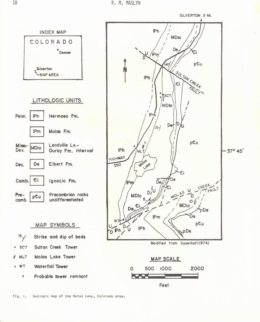
Molas Lake is located along the east side of Colorado Highway 550, 4.7 mi. south of the town of Silverton in the
San Juan Mountains of southwestern Colorado. The area is located slightly north of the Grenadier Highland, a feature
which shows recurrent movement in the Paleozoic (Baars and See, 1965; Spoelhof, 1974). The study area, shown on
Figure 1, is bounded by Sultan Creek and the Sultan Creek fault on the north and by Molas Creek and the Molas Creek
fault on the south, covering a lateral distance of about 1.5 mi.
The Lower Paleozoic section in the area consists of, in ascending order, the Cambrian Ignacio Formation (sandstone
and conglomerate), the Devonian Elbert Formation (sandstone, shale,and dolomite), and the Late Devonian-Early Mississippian
Ouray Formation (limestone and dolomite). Rocks of the Ouray both underly and interfinger with rocks of the Early
Mississippian Leadville Limestone (limestone and dolomite). For this reason, the Leadville and the Ouray are generally
considered as one interval, as originally mapped by Cross, Howe, and Ransome (1904). Although the Leadville and
the Ouray are composed of both limestone and dolomite, the two units have been differentiated in this paper to
aid in the description of the paleokarst features. Where the two units have been differentiated in the study area,
the Leadville is a gray-white very fine-grained calcareous grainstone and the Ouray is a gray-brown to tan fine-grained
crystalline dolomite.
Following deposition, the Leadville-Ouray interval was exposed to erosion. This occurred in midMississippian time
and the unit remained emergent into the Early Pennsylvanian. As a result of this exposure
an extensive karst topography developed with caves, sinkholes, and residual karst towers. The towers are elongated
limestone ridges up to 400 ft. in length and up to 68 ft. in height which extend into and are |
preserved by the overlying Early Pennsylvanian Molas Formation.
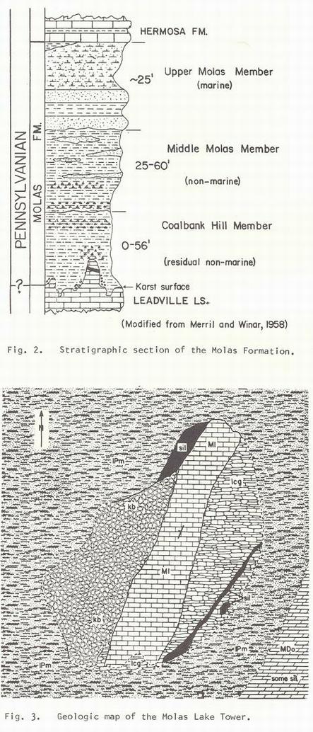
The Molas was originally named by Cross, Howe, and Ransome (1904) for a 140-ft-thlck exposure of red shale, siltstone,
and sandstone along Molas Lake. Their work was extended by Merrll and Winar (1958) who subdivided the Molas into
three members (Fig. 2), based on the relative percentages of kaolinite and illite contained in different portions
of the unit. Their basal Coal bank Hill Member is composed almost entirely of kaolinite and is interpreted to be
a paleosol, possibly a podzol or laterite. The middle member, while still dominantly kaolinitic, contains up to
50 percent illite and is interpreted to be a transported nonmarine deposit. In contrast, the clay minerals in the
upper member are dominantly illite, and the member is interpreted to be a marine deposit formed by the transgression
of the Pennsylvanian sea which covered the area. The Pennsylvanian Hermosa Group overlies the Molas with a gradational
contact.
PALEOKARST FEATURES
During the field study of the Leadville-Ouray paleokarst, several solution features were identified which classified
the type of karst present and indicated the prevailing climatic conditions at the time of its formation. The most
conspicuous of these features are a number of north-south trending nearly linear ridges that project upward from
the Leadville-Ouray surface into the overlying Molas Formation. Three of these ridges were identified as residual
karst towers and were studied in detail. From Molas Creek northwards, they are the Waterfall tower, 200 ft. west
of the waterfall on upper Molas Creek and slightly north of the Molas Creek fault; the Molas Lake Tower, about |
|
|
 |
 |
150 ft. northwest of the registration cabin at Molas Lake; and the Sultan Creek Tower, 1500 ft. south of Sultan
Creek and 500 ft. east of Colorado Highway 550 (Fig. 1). At least 5 other tower remnants were identified in the
area but were not as definitive. Several fossil sinkholes and a filled cave were also noted in the area in addition
to modern karst features.
MOLAS LAKE TOWER
Of the 3 karst towers studied in detail, the Molas Lake Tower is the best exposed, due largely to quarrying in
the Molas Formation along the west side of the tower. The core of the tower consists of a 300 ft-long, 50-ft-wlde,
and 30-ft-high ridge of recrystallized limestone oriented approximately N 20 E. Both sides of the tower are mantled
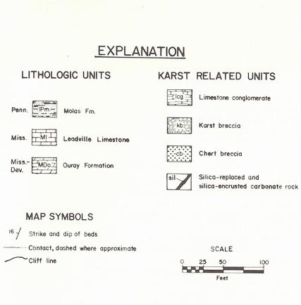
by consolidated scree slopes, noted as a limestone conglomerate (lcg) on Figure 3 along the east side of the tower
and as a Molas-cemented karst breccia (kb) along the west side. With these two fragmental units included, the width
of the tower reaches up to 180 ft.
The mantling limestone conglomerate is clearly visible on Figure 4, as is the closed depression adjacent to the
tower in the foreground. Figure 5 is a view of the north end of the Molas Lake tower showing the tower core, the
limestone conglomerate, and the karst breccia.
The limestone conglomerate is composed of angular to sub-rounded blocks of Leadville Limestone, with minor amounts
of brown siltstone and sandstone matrix material. The siltstone is interpreted to be the accumulated insoluble
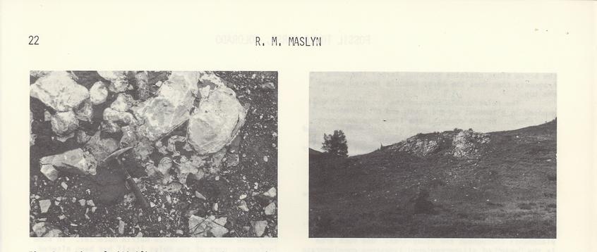
residuum resulting from the solution of the limestone. Most of the limestone fragments range in size from 2 to
6 in.; however, individual blocks may range up to 2 ft. in length (Fig. 6). Similarly, the karst breccia is composed
of angular to sub-angular fragments of Leadville Limestone in Molas siltstone and shale matrix material (Fig. 7).
The |
 |
|
|
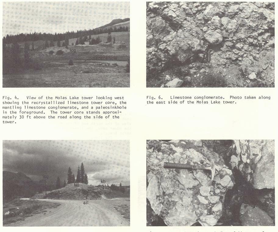 |
| Fig. 5. View of the north eand of the Molas Lake Tower exposed by quarrying, showing the limestone tower core,
the limestone conglomerate, silicified carbonate rock and karst breccia. |
Fig. 7. Karst breccia consisting of limiestone fragments in Molas siltstone. Photo taken at the Molas Lake Tower. |
|
karst breccia fragments are generally in the 1-to 4-in. size range, although there are larger blocks nearly a foot
across. The difference in size of the fragments in the limestone conglomerate and the karst breccia reflects a
rough gradation in size decreasing upwards as might be expected on a scree slope.
The limestone conglomerate and the karst breccia differ in matrix material and to a lesser extent in the size of
the limestone fragments; however, they have similar origins. Both are composed of fragments resulting from solution
and mechanical breakdown of the limestone from the sides of the tower core, which |
accumulated as scree along the sides of the steep-sided towers. Superficially, these accumulations are analogous
to reef talus. The Molas-cemented karst breccia is composed of those rock fragments which were located near the
top of the scree slopes adjoining the towers and were cemented by an early Molas soil and transported Molas material
down to a certain depth below the surface of the scree slope. Those rock fragments below the depth reached by the
Molas cementation contain only minor matrix material and form the limestone conglomerate. In this context, it is
easy to explain why the limestone conglomerate located near the base of the karst breccia located nearer the top.
|
|
|
The relationship between the two units is well exposed in a roadcut at the south end of the Molas Lake Tower. At
the contact, the limestone conglomerate contains only a minor amount of brown siltstone and sandstone matrix material
and its angled contact with the Molas-cemented karst breccia is apparent. Slightly below the contact, angular blocks
of gray chert up to 1 ft. across occur in the limestone conglomerate. Nondeposition of Molas matrix material in
the Mississippian or later erosion has tesulted in the apparent absence of the karst breccia along the east side
of the Molas Lake Tower.
The chert blocks in the limestone conglomerate may be due to silica-replacement of the carbonate rock. Silica occurs
as encrustations and carbonate rock replacements throughout the study area. One such area is the "vein"
of silica-replaced limestone conglomerate along the east side of the tower (Fig. 3). Here the silica occurs both
in a gray to black cryptocrystalline form and as a quartzite composed of gray-black quartz crystals up to 1/8 in.
in diameter. Green-white calcite crystals up to 1/3 in. in diameter line fissures and small vugs in part of the
quartzite. Other vugs up to 4 in. in length are lined with small quartz crystals in the Leadville |
and Ouray carbonates elsewhere in the study area.
The silica replacement is much more common in the limestone conglomerate than in the karst breccia, perhaps as
a result of the permeability differences among the two. In the former, large areas of breccia up to 150 ft. long
have been silicified (Fig. 3). The silicification also extends to the depression adjacent to the tower on the east.
Figure 8 is an ideallized cross-section of a karst tower in the Molas Lake area showing the spatial relationships
of the various units including the silicified rock.
Some of the angular limestone fragments in the karst breccia along the west side of the Molas Lake tower are partially
or totally replaced by silica. Where the replacement has been complete, the limestone clasts are altered to a light-tan,
fine-grained quartz sandstone enclosed in Molas matrix material. In some instances, part of the Molas itself has
been altered as well. Where the replacement of the limestone fragments is incomplete, rims of quartz "sandstone"
surround the unaltered limestone fragment core (Fig. 9). This suggests that the silica replacement of the limestone
clasts begins at the outside of the fragment and progresses inwards. |
|
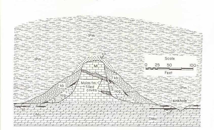
Fig. 8. Ideallized geologic cross section of a fossil karst tower in the Molas Lake area. Horizontal and vertical
scales are equal. See figure 3 for explanation of units. |
|
 |
WATERFALL AND SULTAN CREEK TOWERS
Although neither the Waterfall nor the Sultan Creek Towers are as well exposed as the Molas lake Tower, all 3 share
several common features such as their approximate size, general north-south orientation, recrystallized limestone
core, and Molas-cemented karst breccia.
The Waterfall Tower, located west of the waterfall on upper Molas Creek and slightly north of the Molas Creek fault
(Fig. 1), rises 68 ft. into the Overlying Molas Formation from its base on the dolomite
of the Ouray Formation (Fig. 10). Although much of the tower is concealed by the Molas, a geologic map (Fig. 11)
constructed from the available exposures shows that the tower is approximately 400 ft. long, trending roughly N
20 W, with a width, including the karst breccia, of about 150 ft. A red claystone fill 6 ft wide by 10 ft high
is located in the tower core near the north end. This area of Molas fills a Mississippian - age cave which extended
through the tower. Both the filled cave and a modern sinkhole are located near the axis of a small anticline (Fig.
11).
The Sultan Creek Tower, located 1500 ft. south of the Sultan Creek fault (Fig. 1), is the smallest of the three
towers, extending only 7 ft above the surrounding Molas Formation (Fig. 12). Like the other two towers, it possesses
a core of recrystallized limestone with an adjacent Molas -cemented karst breccia.
No limestone conglomerate or silica-replaced carbonate rock is exposed at either the Waterfall or Sultan Creek
Towers, probably as a result of the limited dissection of both towers. Silicified carbonate rock is present, however,
a short distance east of the Waterfall Tower. The two towers do, however, possess an additional unit, a Molas-cemented
chert breccia, present in minor amounts and not mapped at the Molas lake tower.
Two types of this black chert breccia occur near the tops of the Waterfall and Sultan Creek Towers, as well as
on some of the tower remnants. The first type is composed of angular chert fragments up to 1-1/2 |
in. in length, while the more common type is composed of 1/8-in. to 2-1/2-in. diameter rounded chert pebbles. The
chert fragments may have formed by the same mechanism that silicified the limestone conglomerate and altered the
limestone clasts in the karst breccia to quartz sandstone at the Molas lake Tower. In the case of the chert breccia,
however, this replacement of the limestone fragments to form chert has been complete.
This conclusion is sustained by the occurrence of chert-replaced Mississippian-age brachiopods, possibly derived
from the Leadville Limestone, in the Molas Formation (Merril and Winar, 1958), as well as by the general restriction
of the chert breccias to areas around the upper sections of the towers.
There are remnants of at least 4 other towers in the immediate area of the Sultan Creek tower (Fig. 1), and elsewhere
in the study area, but none is as definitive,
PALEOSINKHOLES
The development of multiple sinkholes in a karst area is a prerequisi·te for the formation of residual karst
towers (Versey, 1972). Such sinkholes must have existed adjacent to the fossil karst towers in the Molas Lake area.
A series of 100 to 300-ft. wide valleys are conspicuous in the Leadville-Ouray interval east of the karst towers,
showing the same general north-south orientation as the towers. Portions of these valleys are clearly composed
of a number of shallow closed depressions, some of which contain ponds and small lakes up to a few hundred feet
in length.
These closed depressions probably represent the paleosinkholes which must have existed adjacent to the towers.
Some of these, such as the 200 ft. wide depression immediately east of the Molas Lake Tower, exhibit a partial
silicified rim and silica encrustation within the depression (Fig. 4). Silicification of the dolomite in the upper
Ouray is also present east of the Waterfall tower (Fig. 11) and around portions of Molas |
|
|
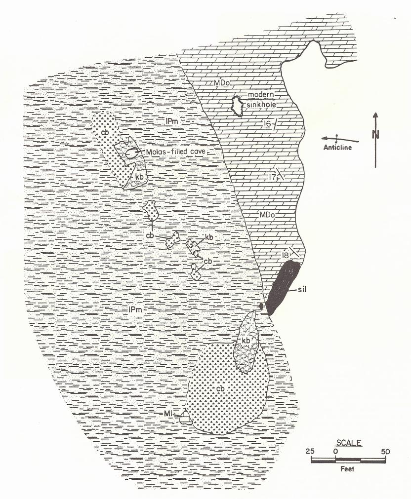
Fig. 11. Geologic map of the Waterfall Tower. See figure 3 for explanation of units. |
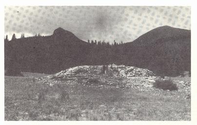
Fig. 12. View of the Sultan Creek Tower looking west. |
Lake. Silica-replaced carbonate rock is also present as a discontinuous rim around some of the paleokarst sinkholes
in the Aspen, Colorado area to the north (Maslyn, 1976). The irregularly shaped Molas Lake itself probably occupies
a number of coalesced paleosinkholes (Fig. 1).
ORIGINS AND CONTROLS OF THE PALEOKARST FEATURES
The north-south trend of the 3 karst towers, as well as the paleokarst sinkholes, is roughly perpendicular to the
trends of the Sultan Creek and Molas Creek faults. The latter has been identified by Spoelhof (1974) as a feature
active in the Mississippian. The author concurs and feels that the Sultan Creek fault was active then as well.
These two faults may have been major contributors to the degree of tower karst development in the study area by
imposing the strong joint pattern required for tower karst development on the Leadville-Ouray interval.
There is a general northward decrease both in the height end length of the 3 karst towers away from the Molas Creek
fault and the Grenadier Highland. The heights of the Waterfall, Molas Lake, and Sultan Creek towers are approximately
68 ft., 30 ft., and 7 ft., respectively. Similarly, their respective lengths are approximately 400, 300, and 200
ft. This size variation reflects an additional control more regional in scope.
The red Molas siltstones and shales that overlap the Molas Lake tower locally possess a high iron-oxide content.
The source of the iron and silica observed in the study area may be determined from an examination of modern tower
karst.
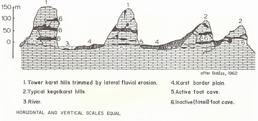
Modern tower karst is restricted to areas with a humid sub-tropical to tropical climate below 30 degrees latitude.
Some of the areas where it is best developed are on the island of Java, in North Vietnam, and in southern China.
Figure 15 is a cross sectional view of modern tower karst in China (Balazs, 1962). Of note in the illustration
are the scree slopes adjacent to the towers and the caves which extend through the tower cores, analogous to the
breccias along the sides of the paleokarst towers and the filled cave present in the core of the Waterfall Tower.
In one other area of modern tower karst, the island of Jamaica, a lateritic soil analogous to what the Coalbank
Hill Member
|
|
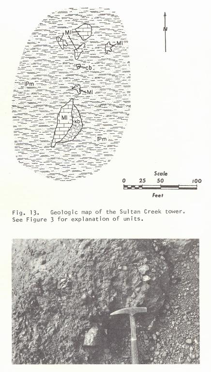
Fig 14. Chert breccia in Molas matrix material. |
of the Molas Formation represents is developed adjacent to the towers (Versey, 1972).
The silica present as replacements and encrustations on the Leadville - Ouray interval and the iron content of
the Molas Formation may be explained in the context of sol-forming processes. The silica observed in the study
area was derived through the ferralitization of the lateritic soil and precipitated by the carbonate rock. Silica
leaching from such a tropical soil is reported by Bridges (1970). At the same time, the silica is removed from
the soil, and iron and aluminum are concentrated. |
|
|
 |
Tower paleokarst as in the Molas Lake area is analogous to late-mature and old-age tower karst present in some
tropical areas today. This type of karst develops under a set of specific geologic controls. The most important
of these are: (1) cl imatic, requiring a humid, sub-tropical to tropical climate; (2) structural, requiring the
presence of strong jointing; (3) lithologic, favoring a massive finegrained limestone; and, (4) topographic, requiring
adequate topographic relief for the towers to develop.
ACKNOWLEDGMENTS
This paper is the result of a senior thesis research project undertaken by the author at the Colorado School of
Mines. I wish to thank the Colorado School of Mines Research Foundation for providing partial financial assistance,
Dr. Robert W. Spoelhof for providing valuable comments and discussion, Dr. Cooper B. Land, Jr., who graciously
read and provided suggestions on earlier versions of the manuscript, and especially Dr. Robert J. Weimer, who first
suggested the topic, directed the research, and provided valuable comments and. suggestions.
REFERENCES
Baars, D. L., and See, P. D., 1968, Pre-Pennsylvanian stratigraphy and paleotectonics of the San Juan Mountains,
southwestern Colorado: Geol. Soc. Amer. Bull., v. 79, no. 3, p. 333-350. |
Balazs, D., 1962, Beitrage zur Spelaologie des sudchinesis Karstgebietes: Karszt-es barlang-kutatas, v.2, p. 3-82.
Bridges, E. M., 1970, World Soils, Cambridge University Press, Cambridge, England, 114 p.
Cross, C. W., Howe, E., and Ransome, F. L., 1904, Silverton, Colorado: U. S. Geol. Survey Geol. Atlas Folio No.
120, 34 p.
Maslyn, R. M., 1976, Late Mississippian paleokarst in the Aspen, Colorado area: unpub. Colorado School Mines M.Sc.
thesis, 96 p.
Merril, W. M., and Winar, R. M., 1958, Molas and associated formations in the San Juan Mountains area, southwestern
Colorado: Am. Assoc. Petroleum Geologists Bull., v. 42, no. 9, p. 2107-2132.
Spoelhof, R. W., 1974, Pennsylvanian stratigraphy and tectonics in the Lime Creek-Molas Lake area, southwestern
Colorado: unpub. Colorado School Mines PhD thesis, 193 p.
Versey, H. R., 1972, Karst of Jamaica, in Herak, Milan, and Stringfield, V. T., eds., Karst; Important karst regions
of the northern hemisphere; American Elsevier, Amsterdam, New York, 551 p. |
|
|
| |
| Copyright (c) 2006 by R. Mark Maslyn - All Rights Reserved |
| |
|
Return to CarbonateCreek.com Home Page
|