Chasing the Water With Scallops in Cave of the Winds
by R. Mark Maslyn
Abstract
Scallops, dish-shaped indentations in cave passages indicating water flow direction and
velocity, can help determine paleoflow directions in cave systems. Scallops up to 13 feet (4m) in length occur
in Cave of the Winds near Manitou Springs, Colorado. Since scallop length is inversely proportional to water velocity,
the large size of these scallops indicates slow water flow at the time of their formation.
Cave of the Winds is a mixing waters cave, formed by phreatic ground water mixed with upwelling artesian C02-rich
mineral spring waters. As such, the paleoflow directions determined from measurements throughout the cave reflect
these two hydrologic regimes. The phreatic water flow indicated by scallops in most of the cave is aligned with
the regional north-south hydraulic gradient. Cave passages near the southwestern boundary of the cave show local
reversals of the water directions and flow loops in the cave, reflecting the additional input of the mineral waters
near the spring infiltration zones.
What Are Scallops?
Scallops are dish-shaped depressions formed by eddies in flowing water m cave walls, floors
and ceilings (Ford and Williams, 1989). These indentations can range in length from less than an inch (<2.5
cm) to several feet (>1m), but are most commonly found towards the smaller size dimensions. The author has previously
reported on large scallops, up to 13 feet (4m) in length, occurring in Cave of the Winds (Maslyn, 1982).
Scallops can form both in caves and on the surface where flowing water is in contact with a soluble material. Local
eddies in the water flow produce turbulent swirls in the water, which dissolve away the bedrock. Scallops are slightly
asymmetrical, with the downstream end being shallower than the upstream.
Figure 1 from Curl (1974) is an illustration of how a scallop forms. Upstream is to the left in the diagram. At
point 1 the water flow separates from the main current at the upstream edge of the scallop starting the formation
of an eddy. Within the eddy at point 2 the water flow type changes from laminar to turbulent. Water swirls in an
eddy at point 3, entirely within the scallop. Lastly, at point 4 the water flow exits the downstream (shallower)
edge of the scallop to continue downstream.
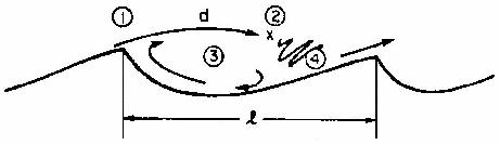
Figure 1: Water flow directions during the formation of a scallop. Upstream is to the left in the diagram. Diagram from Curl, (1974).
Several authors have described similar meter scale or larger wall, ceiling, or floor indentations in limestone caves similar to the scallop features found in the Cave of the Winds system and attributed them to differing processes.
Frank, et al., (1998) described meter scale indentations on walls, floors, and ceilings of Flank Margin caves at Isla de Mona near Puerto Rico. These features were termed "cusps" rather than scallops to distinguish their environment of formation m non-stream caves. They proposed that the cusps formed from convective water flow.
Hill, (1987) described scallops from decimetres to several meters in length occurring on cave walls and ceilings in Guadalupe Mountain area caves. She interpreted these features to be "air scallops."
Jagnow (1990) in a study of the paleohydrology of Kartchner Caverns in Arizona interpreted the indentation features he saw there as large water generated scallops and classified them into three size ranges with the largest features being those greater than 3 ft (0.91 m) in length. These features were used to map the paleohydrologic flow directions and relative velocities in the cave.
The wall indentations present in Cave of the Winds show the classic scallop morphology and are consistent in terms of water flow direction and velocity within a given passage. Cave of the Winds has been interpreted as a cave formed under phreatic groundwater/mineral spring water mixing zone conditions (Luiszer, 1997), consistent with a water rather than air generated origin for the indentations. Therefore the author interprets these features as true water generated scallops.
Scallops in Cave of the Winds
Cave of the Winds is a 1.8 mile (3.0 km) long cave system near Manitou Springs, Colorado (Burger, 1997). Cave development occurs across an
interval of three carbonate units, the Ordovician Manitou Limestone, Mississippian Williams Canyon Formation, and Mississippian Leadville Limestone. Most passage development however occurs in the Manitou Limestone.
Although originally two separate commercial caves, the historic Cave of the Winds and the Manitou Grand Caverns system were connected by excavating dirt-filled cave passageways in the 1920's. Hydrologically these two caves are clearly part of the same system and are described as such in this article.
Previous work has shown that in the Williams Canyon area during the deposition of the alluvium over Cave of the Winds, the surface water was flowing from the west to the east and underground paleoflow directions were from north to south. Phreatic speleogenesis at the cave was enhanced by C02-charged mineral waters entering the cave from below and mixing with the surface derived phreatic groundwater. The mixed waters precipitated unusual mineral deposits rich in arsenic, lead, iron, and manganese Luiszer (1997).
Passage development follows three major joint directions: north-south, northeast-southwest and northwest-southeast. Passages formed along the first two directions tend to be strongly joint-controlled, while passages formed along the third set of fractures tend to be less strongly developed.
The longest passages in the cave follow the north-south joint trend. Examples of these passageways include the Grand Concert Hall, the largest room in the cave, Majestic Hall, Yukon Trail, and Silent Splendor.
Secondary and significant passage development occurs along northeast-southwest trending passages such as the Northeast Extension, Thieves Canyon, and Canopy Hall. The third major joint trend, northwest-southeast, is best developed along the southwestern margin of the cave from the Spider's Den to Canopy Hall. Passages developed along this joint trend include the Temple of Silence, Fat Man's Misery, the Old Curiosity Shop, and the Valley of Dreams/Adventure Room area.
Throughout the cave, scallops occur singly, in groups, or chains. Scallops in the cave range from approximately 1.7 feet (0.5 m) to 13 feet (4m) in size with most scallops clustering around the 4-5 ft (1.2-1.5 m) size.
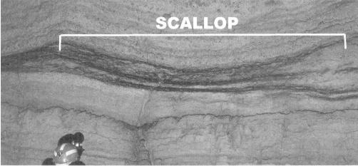
Figure 2: Photograph of a scallop in the Grand Concert Hall portion of Cave of the Winds showing the characteristic "C" shape. The shallower side of the scallop points in the direction of water flow. In this case the water flow is from left to right. Note the caver's helmet for scale. [Carolyn Cronk photo]
A similar but smaller series of rosary bead scallops occurs on the west wall of Majestic Hall (Figure 3). Note that the scallops show a consistent flow direction from left to right as well as the head to tail relationship.
Paleoflow Determinations in Other Caves Using Scallops
Scallops can be used to determine paleoflow velocity and direction. Scallop size is inversely
related to the water velocity, with the smaller scallops resulting from faster water flow. Curl (1974) developed
equations for relating the scallop length to the water flow velocity. Pisarowicz and Maslyn (1981) using data from
Spring Cave in northwestern Colorado verified these equations. Their work indicated a good correlation between
the measured water flow volumes and the predicted flow volume based on scallop measurements.
Scallops have also been used in several studies to reconstruct paleoflow directions including work by Drake and
Borden (1981), White and Deike (1989), and more recently by Auler (1998). In the last case, Auler was able to reconstruct
the paleoflow directions in two adjacent basins in Brazil using scallops in isolated cave segments.
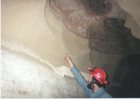
Figure 3: A chain of scallops in Majestic Hall. Note the consistency in size of the scallops, each approximately 1.7 ft (0.5 m) in length. Water flow direction is from left to right in the picture. [Mark Maslyn photo]
Chasing the Water in Cave of the Winds
Scallops throughout the cave were measured to determine their size and the indicated water
flow directions. Figure 4 is a map of the Cave of the Winds system with paleoflow directions as determined by the
scallops indicated by arrows. Arrow lengths do not indicate relative water velocities.
As expected, many of the large north-south trending major passages, including Yukon Trail, the Grand Concert Hall,
Lover's Lane, and Silent Splendor show paleoflow directions aligned with the north to south hydraulic gradient.
This agrees with the phreatic water flow direction evidence derived from other sources.
Paleoflow directions from scallops in the northeast-southwest set of highly joint controlled passages also reflect
the expected down-gradient flows. With a north-south hydraulic gradient the scallops indicate flow from the northeast
to the southwest. Examples include Canopy Hall, the Horseshoe Tunnel passage, Thieves Canyon, and the passage connecting
the Grand Concert Hall with Reception Hall in Manitou Grand Caverns.
Paleoflow directions in the northwest-southeast trending passages are more complex with a series of anomalous paleoflow
indications and water flow loops in the passages developed along these joints reflecting different hydrologic conditions.
Paleoflow Directions Influenced By Rising Mineral Spring Waters
An imaginary line drawn on the cave map (Figure 4) along the southwestern edge of the cave from the Adventure Room to Zephyr Dome (located 100 feet west of Canopy Hall), connects many areas where the scallops show conflicting directions. In contrast to the north-south water flow indicated in the other areas of the cave, scallops in many of these passages show a reversal in water flow direction, from south to north, or into the cave.
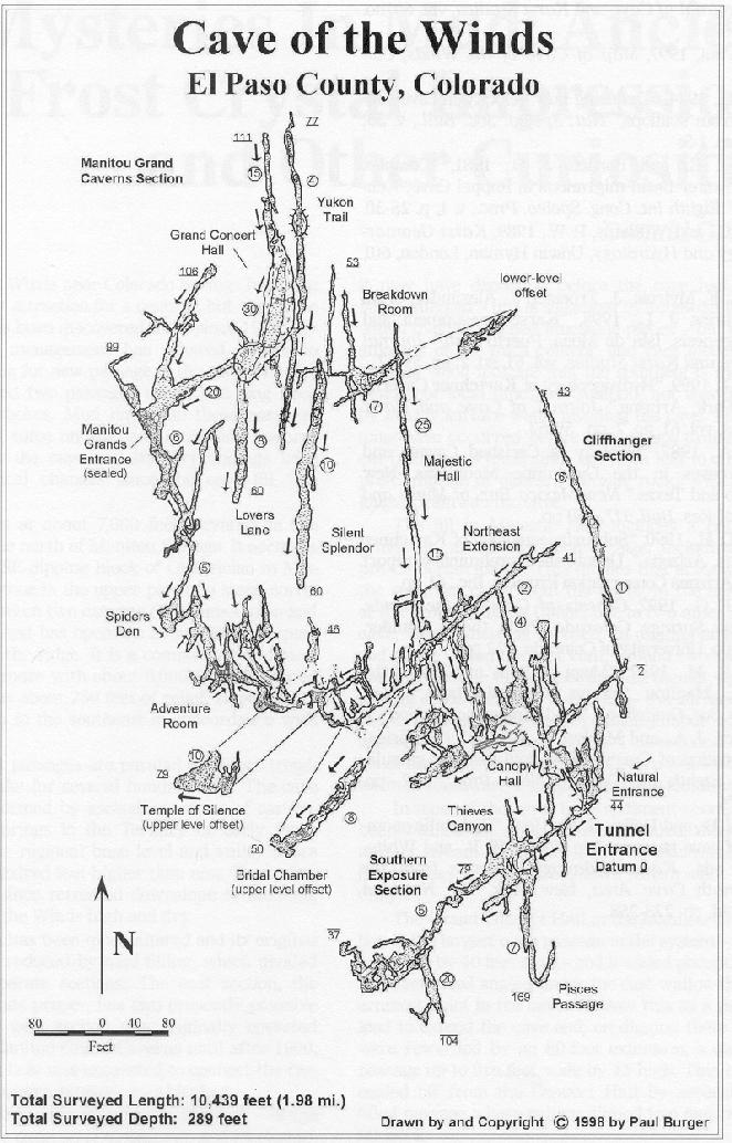
Figure 4. Map of the Cave of the Winds system from Burger (1997). Paleoflow directions are indicated with arrows. Arrow length does not indicate relative velocities. Note the predominant north to south paleoflow in the joint controlled passageways and the mixed paleoflow directions along the southwestern border where the upwelling mineral spring waters mixed with the phreatic ground water.
On the surface, this portion of the cave is adjacent to the northeastern boundary of sinkhole believed to indicate the paleovalley and mineral water spring basin in existence at the time of this level of the cave's formation (Luiszer, 1997). Regional water flow, as reflected in the Grand Concert Hall scallops, traversed the passages from north to south to the master stream, Fountain Creek, flowing in the paleovalley At the same time, C02-rich mineral spring waters ascended into the paleovalley and the cave from below, probably as a number of point source inputs.
It may be that the Adventure Room with its many radiating passages and pervasive limestone dissolution features was a locus for a point input of mineral spring waters. Such an input could cause a local change in the hydraulic gradient and resulting water flow directions. The paleoflow directions indicated by the scallops support this conclusion. Similar flow reversals can be found in other passages along this imaginary line.
Note that the line also overlays the Thieves Canyon in the Lower Cave section of Cave of the Winds. Why then does the normal joint controlled flow occur in these passages along and south of the paleoflow input line? The answer is that the Thieves Canyon area is approximately 125 feet below the level of the southeast trending section of the main cave level mentioned previously, and formed at a later time when stream down-cutting had moved the paleovalley and spring basin lower and southward, perhaps in the
Conclusions
Scallops in the Cave of the Winds system have been successfully used to determine paleoflow
directions and indicate areas of water input to the
cave. In the northern and eastern portions of the cave, water flow directions coincide with the regional hydraulic
gradient from north to south. Water flow in the southwestern section of the cave shows the influence of the artesian
mineral spring waters entering the cave and changing the paleoflow directions.
Knowledge of paleoflow directions can be used as an aid in determining where to search for new cave passages.
Acknowledgments
The author wishes to thank several individuals for their contributions to this paper. I would like to thank Peter Blomquist, Cyndi Mosch, Rick Rhinehart, Carolyn Cronk, Thom Engel, Todd Hitch, and Steve Ingram for assistance measuring the scallops, and Carolyn, Bob, and Wesley Cronk for their photographic work. The author particularly benefited from discussions with Dr. John Mylroie of Mississippi State University and Dr. Fred Luiszer of the University of Colorado.
References Cited
Auler, A. S., 1998, Base-level changes inferred from cave paleoflow analysis in the Lagoa
Santa Karst, Brazil: Journal of Cave and Karst Studies, vol. 60, no. 1, p. 58-62.
Burger, Paul, 1997, Map of Cave of the Winds, Colorado.
Curl, R. L., 1974, Deducing flow velocity in cave conduits from scallops: Nat. Speleo. Soc. Bull., v. 36, no. 2,
p. 1-5.
Drake, M. E., and Borden, J. D., 1981, Complex groundwater basin migrations m Roppel Cave, Kentucky: Eighth Int.
Cong. Speleo. Proc., v. 1, p. 28-30.
Ford, D. C., and Williams, P. W, 1989, Karst Geomorphology and Hydrology: Unwin Hyman, London, 601 p.
Frank, E. F., Mylroie, J., Troester, J., Alexander, C. A., and Carew, J. L., 1998, Karst development and speleogenesis,
Isla de Mona, Puerto Rico: Journal of Cave and Karst Studies, vol. 60, no. 2, p. 69-72.
Graf, C. G., 1999, Hydrogeology of Kartchner Caverns State Park, Arizona: Journal of Cave and Karst Studies, vol.
61, no. 2, p. 59-67.
Hill, C. A., 1987, Geology of Carlsbad Cavern and other caves in the Guadalupe Mountains, New Mexico and Texas:
New Mexico Bur. of Mines and Mineral Res. Bull. 117, 150 p.
Jagnow, D. H., 1990, Subsurface geology of Kartchner Caverns, Arizona: Unpublished preliminary report to the Arizona
Conservation Projects, Inc., 61 p.
Luiszer, F. G., 1997, Genesis of Cave of the Winds, Manitou Springs, Colorado: Ph.D. thesis, Boulder, Colorado,
University of Colorado, 122 p.
Maslyn, R. M., 1982, Mega scallops in Cave of the Winds, Manitou Springs, Colorado (abs): Nat. Speleo. Soc. Guidebook,
Bend, Oregon convention.
Pisarowicz, J. A., and Maslyn, R. M., 1981, Empirical confirmation of Curl's (1974) flow velocity calculations:
Eighth Int. Cong. Speleo. Proc., v. 2, p. 772-774.
White, W B., and Deike, G. H., 1989, Hydraulic geometry of cave passages, in White, W B., and White, E. L., eds.,
Karst Hydrology Concepts from the Mammoth Cave Area: New York, Van Nostrand Reinhold, p. 223-258.
Copyright (c) 2006 by R. Mark Maslyn
Last Updated May 13, 2006